Icon: 
Function: GeometryInfo
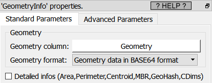
Property window:
Short description:
Extract information from Geometries
Long Description:
The Extracted informations are:
•GeometryType: it can be: POLYGON,MULTIPOLYGON,POINT, MULTIPOINT,etc.
•NPoints: Number of points inside the geometry
•IsValid: 0 or 1
•NRings: Number of Rings:
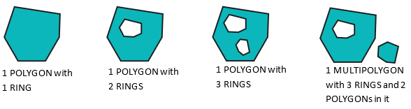
•NumGeometries: The Number of geometries inside a MULTI-geometry: For example: The number of POLYGON inside a MULTIPOLYGON geometry
•SRID: see previous section 5.10.10. for more details on SRID
•Dimension: 0 for POINT, 1 for LINE, 2 for POLYGON
•NDims: 2 (when you have Lattitude and Longitude) or 3 (when you have Lattitude, Longitude and Elevation)
•Is3D: when nDims=3
•IsEmpty: 0 or 1
•IsSimple: 0 or 1
If you check the “detailed info” checkbox, you also get:
•Area: The area is usually expressed in m² (i.e. divide by 1.000.000 to get it in Km²). In particular, for the SRID 4326, you also directly get the area in m² (personnaly, I expected the area in degree² for the SRID 4326 but it’s in m². Cool!).
•Perimeter: The Perimeter is usually expressed in m (this is also true for the SRID 4326 !).
•Centroid: the POINT at the center of the geometry (in WKT format). It might be outside the POLYGON if the geometry as a “U” shape.
•Envelope: the minimum bounding rectangle (MBR) around the geometry (in WKT format)
•GeoHash: the geohash of the POINT (null if it’s not a POINT)
•CoordDimension: most of the time: “XY”, sometime: “XYZ”
To remind you, a .shp file can only contain 1 type of geometry (e.g. it cannot contains both the POLYGON and the MULTIPOLYGON geometry type) and 1 unique SRID. Using the ![]() geometryInfo action is usefull to see if you can export your Anatella table to a .shp file: if you see several different geometry types or multiple different SRID, then the exportation will fail (this is the most common source of error when exporting to a .shp file).
geometryInfo action is usefull to see if you can export your Anatella table to a .shp file: if you see several different geometry types or multiple different SRID, then the exportation will fail (this is the most common source of error when exporting to a .shp file).