Icon: 
Function: bingIsochrones
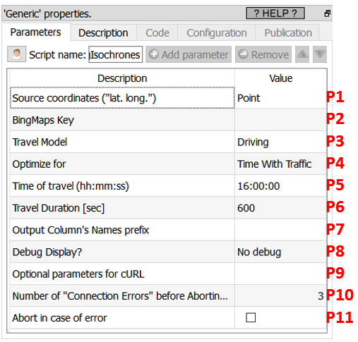
Property window:
Short description:
Compute Isochrones using Bing
Long Description:
This Action also works when accessing the web through a PROXY server: Please consult the section 5.1.9.2. for more details on how to setup the parameter P9 for web-access through a PROXY server.
To use this Action, you’ll first need to get a “BingMaps Key” from the Bing Maps website (parameter P2). Please see the previous section 5.10.4.1 for more details on how to get this key.
Once you have completed the “setup process” described in the section 5.10.4.1, you can use this action. This action computes the isochrone polygon for all the given starting points (Parameter P1). The polygon in output is in WKT format: if required, use the ![]() ConvertGIS Action (see section 5.10.16.) to convert it to another format.
ConvertGIS Action (see section 5.10.16.) to convert it to another format.
This action returns time-specific, isoline polygons for the distance that is reachable from a given location and supports multiple modes of transportation (i.e., driving, walking, and public transit). Use this solution to plan the area that can be reached from a designated starting point within a set time period. The isoline polygon area, good for visualization, can be used to filter for spatial queries, which opens up a wide variety of applications for spatial filtering. Here are some use cases of where you might use isochrones:
•Store Locators – Show me all users that are within 10 minutes of a shop.
•Stolen Vehicle Recovery – Where could a vehicle have travelled to since it was stolen.
•Real Estate – Limit search results such that only those that are within the users preferred commute preferences to work. For example, show me all homes that are within a 30-minute drive of work.
•Job Search Sites – Show all jobs that are within 45 minutes of my home when taking public transit.
•Geofence Generation – Generate a polygon that be used as a geofence that alerts users when they are within a certain travel time or distance of a location.
•Field management – Show me all workers who are within a 15-minute drive of a job.
•Recreation – Where could I walk to within 30 minutes of where I am.
•Emergency Services Planning – Where could an emergency vehicle travel too within 5, 10, and 15 minutes.