Icon: ![]()
Function: bingMapGeocode
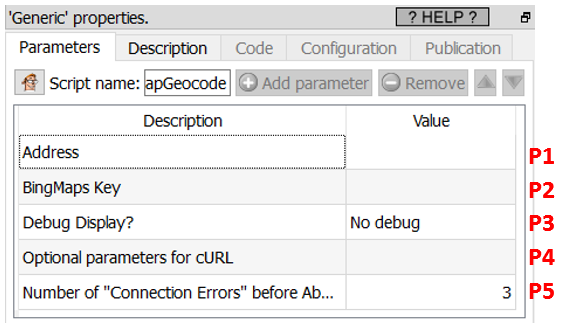
Property window:

Short description:
Geocode addresses using Bing
Long Description:
This Action also works when accessing the web through a PROXY server: Please consult the section 5.1.9.2. for more details on how to setup the parameter P4 for web-access through a PROXY server.
To use this Action, you’ll first need to get a “BingMaps Key” from the Bing Maps website (parameter P2). Please see the next section 5.10.4.1 for more details on how to get this key.
Once you have completed the “setup process” described in the section 5.10.4.1, you can use this action. This is pretty straightforward: Just give the column (in parameter P1) that contains some postal addresses “as-if” these addresses where written directly inside BING. Then, Anatella will give the following 16 columns in the output table:
Latitude, Longitude, Confidence, statusCode, statusDescription, authenticationResultCode, copyright, EstimatedTotal, AddressLine, AdminDistrict, AdminDistrict2, CountryRegion, FormattedAddress, Locality, PostalCode, MatchCode.
Each call to the BING engine is slow (because all internet-based REST api calls are always slow). So, you want to avoid to geocode 2 times the same address (to avoid losing time). To be sure to save all the geocoding results on the hard-drive as soon as they have been extracted from BING, you should use the writeSQLITE box with the option “Commit every 1 row” enabled:

In the above graph, the addresses to geocode are directly extracted from an Excel file. Ideally, you should have a slightly more complex Anatella graph that removes all the already-geocoded addresses (that are stored inside the SQLite file) from the input of the ![]() bingMapGeocode Action (to avoid to geocode 2 times the same address).
bingMapGeocode Action (to avoid to geocode 2 times the same address).