Icon: 
Function: ExpandGIS
Property window:
|
|
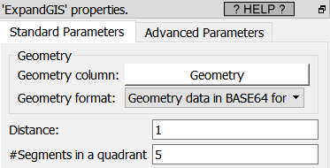
Short description:
Expand the contour of Geometries
Long Description:
Self-explanatory. See the section 5.10.10.1. for an example of use.
This Action assumes that the geometries are defined in a standard PLANAR coordinate system (i.e. not inside the SRID 4326), so for best results, you shouldn’t use it inside the SRID 4326 4326 (i.e. use the ![]() ReprojectGIS action to do all computations in a better SRID).
ReprojectGIS action to do all computations in a better SRID).