|
<< Click to Display Table of Contents >> Navigation: 5. Detailed description of the Actions > 5.4. Join Tables > 5.4.10. GIS Join (High-Speed
|
Icon: ![]()
Function: JoinGIS
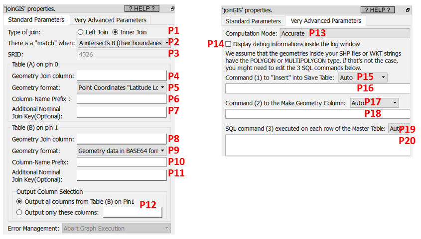
Property window:
Short description:
Computes a GIS join.
Long Description:
Computes a join between two table (“Table A” and “Table B”) using geographical informations.
As usual, the “Table B” is the “Slave” table: It’s completely loaded into memory at the start of the execution, so it should be “small enough” to fit into your RAM memory. To use less RAM, you can load into memory a sub-selection of the columns from “Table B” using the parameter P12.
The different options for the parameters P5 and P9 are:
•Point Coordinates "Latitude Longitude".
This format is self-explanatory. The Latitude and Longitude must be stored in the same column, separated with a space char, in decimal degree.
•Rectangle "Latitude1 Longitude1 Latitude2 Longitude2"
This format is self-explanatory. The 4 numbers must be stored in the same column, separated with a space char, in decimal degree.
•Geometry data in WKT format
You can create/draw WKT strings very easily using this interactive mouse-based editor:
•Geometry data in HEX format
This format is for compatibility with PostGreGIS.
•Geometry data in BASE64 format
This is the default geometry format that is given as output of the ![]() loadShape action (see the section 5.2.31 for more details about this action). Basically, you get a “Geometry” column from your .shp Shape files using the
loadShape action (see the section 5.2.31 for more details about this action). Basically, you get a “Geometry” column from your .shp Shape files using the ![]() loadShape action and you use it here.
loadShape action and you use it here.
The parameter P3 defines the SRID that is used for the computation (more details on this subjection in the section 5.2.31). Most of the time, you must use the 4326 SRID. When you compute a join between two .shp Shape files, you can freely choose the SRID (but please make sure that both shape files are using the same SRID).
Behind the scene, this Anatella action uses the very efficient “Spatial Index” included inside the SpatialiteGIS library to speed-up the computations.